Sunday, May 29, 2011

May 27/28

May 27
We had a lazy day today with a little shopping in Moab, lunch at the local brewery, and reading time in the afternoon. Every other vehicle in Moab is a 4x4 and the place is hopping with the Memorial Day weekend. After cooking three meals a day for a week, we decided eating out in Moab would be a nice change. The Sunset Grill high up on the hill overlooking Moab and the red rock cliffs was our choice for dinner. It is in the home that Charlie Steen built in the fifties after making it big in uranium mining. The house is three stories and a little tired at this point but it must have been quite the place in the fifties. He had a colorful past working as a geologist in South America and then in the oil fields in Texas. He ended up getting fired for insubordination and nobody would hire him. In 1950 he came out west after hearing that the government was subsidizing uranium mining. He and his family lived in a trailer and then a tarpaper shack as he continued drilling and coming up with nothing. He couldn’t afford the Geiger counter others were using. The story goes that two years later he went into Moab for gas with rock he had drilled out and put in the back of his beat up station wagon The gas station attendant came out with a Geiger counter and it went crazy! He had just found the largest concentration of uranium in the four corners area and became a multimillionaire over night. He spent like crazy. One story is that he couldn’t get good TV reception so he would fly over Moab in his private plane so his kids could watch their favorite TV shows. The story on the back of the menu ended with his move to Colorado, but the reality was that the money ran out and other ventures failed causing him claim bankruptcy in 1968. He must have had quite a ride living high while the money lasted! It is now a restaurant with every seat having a great view.
May 28
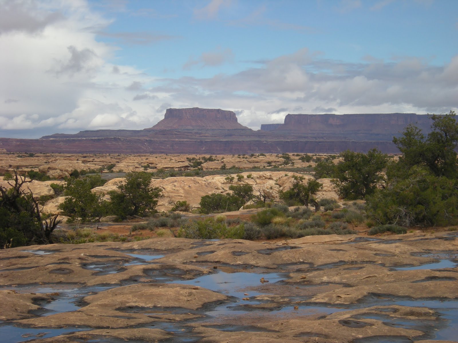
We had breakfast in town and headed north to make a circle drive up the Scenic Byway on Hwy 128 along the Colorado River. The river is 1,450 miles long, supplies 29 million people with water and irrigates 3.5 million acres of farmland. It has transformed desert land into cities, farms and recreations areas. Even now when it is running so high and fast it is hard to believe it can benefit so many. The Tamarisk plant now lines the river banks and is a worry at this point. It drinks about 17,000 gallons of water a day from the river! It is an invasive plant that made it’s way from Asia in the 1940’s. An eradication project has been set up but it must seem overwhelming. We drove up the river as far as the Dewey suspension bridge. It must have been quite a project when it was built in 1916. It had wooden planks and was strong enough to hold six horses, three wagons, and 9,000 pounds of supplies per crossing. It burned in 2008 and is now just a skeleton. There are still a couple of the original boards attached. We drove back to Castle Rock and Red Rock Cliff Resort. So many movies, TV shows and commercials were made in this area and the resort holds the memorabilia in a movie museum. With John Ford beginning to make films in the area in 1939, George White, a local Utah boy, founded the Moab to Monument Valley Film Commission in 1949 with the filming of Wagon Master. It holds the title as the longest running film commission in North America. Movies like Indiana Jones, TV shows like MacGyver, and the Malboro Man commercials all have some the area’s landmarks as their backdrops. It continues to help this area economically with locals being hired to build sets and play bit parts in many of the films. The museum did an excellent job showing how the locals have been involved. The resort is right on the river at a class 3 rapid. They offer a delicious Bar-B-Q lunch stop for visitors like us and river rafters. We sat on the grass having our burgers and looking out at the river and red rock cliffs. We watched a couple of groups go over the rapids as they screamed with delight. It brought back memories of our rafting trips. The circle drive took through Castle Valley and up into the La Sal Mountains.


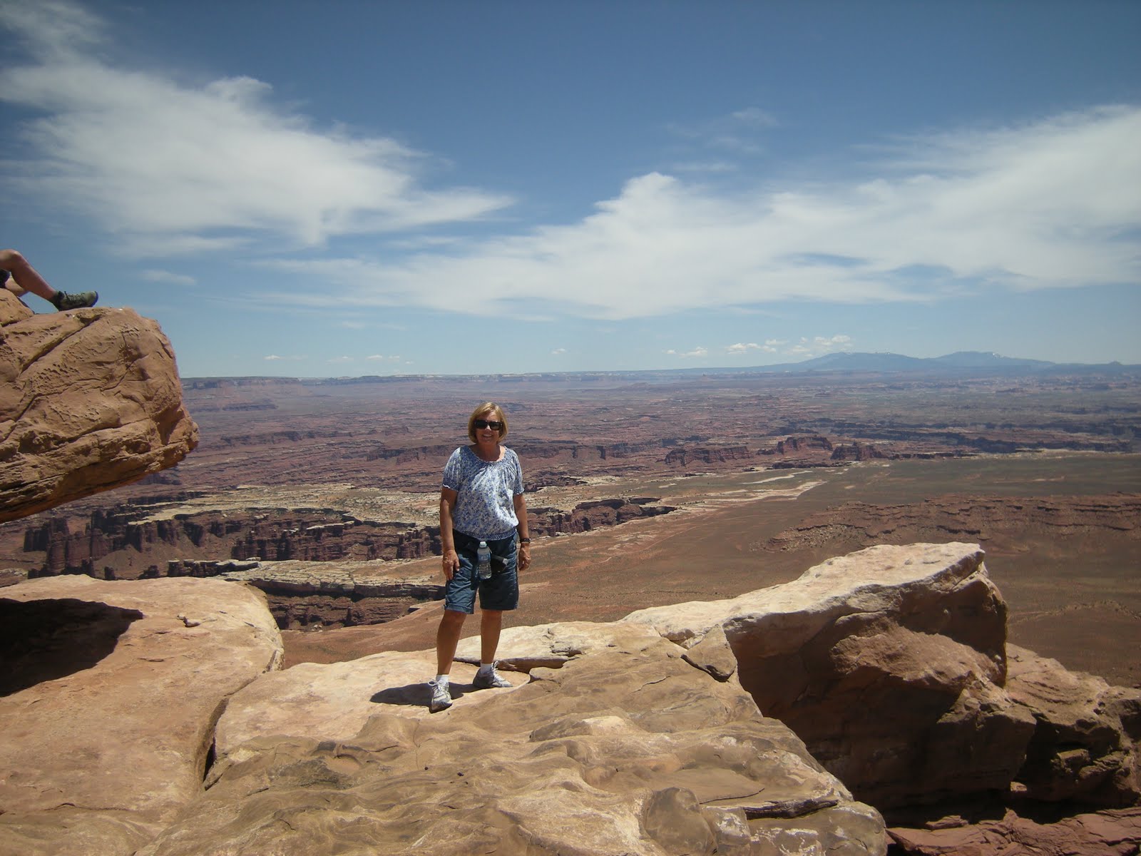
Look who we ran into!

Rafts Lined Up along Colorado River - Red Cliff Lodge


WildFflowers and Cactus Are Blooming


Thursday, May 26, 2011

Canyonlands

May 24
We drove up the road a few miles to Archview RV Park for the next couple of days so we can see Canyonlands. The only campground in the northern part of the park has only 12 sites and no water. We decided full hookups was the way to go! We drove in the park to the Visitor Center and got acquainted with this part of the park. We had been to the southern section last week when we saw the needles area. Later in the afternoon Christy and I drove up to Green River to see the John Wesley Powell Museum. The town got a zero in our book but the museum was great. It gave and excellent history of Powell’s life including his journey down the Green and Colorado Rivers in 1869 and again in 1871. He started his incredible trip clear up in Wyoming. But is also included an all inclusive history of the Green River. Very interesting.
May 25
Canyonlands NP preserves canyon after canyon on the Colorado Plateau for us to marvel at. It is divided into three areas with the Needles to the south, the Maze to the west of the Green River and the Island in the Sky area in the center high above the Colorado and Green Rivers. It has an amazing dirt road that skirts the entire park 1,000 feet below along the White Rim. You have to make a reservation to take the two to three day trip with a jeep. Norm is already looking into a 4 wheel drive vehicle. We have put the jeep trip on our list for “some day.” We enjoyed the rim today with magnificent vistas of canyons on both sides of the road. After stopping at a couple of viewpoints, we took the easy .5 mile walk out to Mesa Arch. The view through the arch out to the canyon and La Sal Mountains was spectacular. At sunrise the arch glows with oranges and golds. Too bad I won’t get that camera shot but sunrise is at 6:00 now! Our get up time is closer to 8:00. Looking through the arch you can see Washer Woman’s Arch is the distance. Our next hike was down the road to White Rim Overlook with a two mile hike of vista after vista of canyons and the Colorado River. Standing at the end of the trail along the cliff we could see for miles. It looked like you could touch the snow covered mountains 35 miles away. We got our first real good glimpse of the Navajo stone white rim that winds in, out and backwards 1,000 feet below the rim we were standing on yet 1,000 feet above the two rivers. Looking down on the road it was fun imagining the jeep trip we will make someday. There was a nice picnic table waiting for us when we got back to the parking lot. At the end of the road we took the two mile hike out to Grand View Point. We could see both the Green River and the Colorado River and the canyons they formed before coming together at the Confluence further down the canyon. From then on it is the Colorado river making its way toward Las Vegas. The rivers are calm and meandering until they come together and then it is one wild ride for about 15 miles of rapids. River rafters have to be ready for rapid after rapid as the river heads south. The views were amazing at the point. We were standing on a rock high above the valley floor (2,000 feet) looking out in at least an almost 300 degree circle out to canyons clear down to the Needles area in the far distance. Three snow covered mountain ranges were framing the canyons. What a sight! After climbing up and down stairs and over and around boulders with our three hikes, we decided to take the last scenic road out to Upheaval Dome tomorrow.


Chris and Norm at Mesa Arch


Mesa Arch Looking Out to Washer Woman Arch and Canyons


Chris and I at tthe Lookout Down to Shaffer Road


Looking Down 1,000 feet to the White Rim and the Jeep Road
This is on the Colorado River side of the Island in the Sky.


Chris and Norm at Grand View Point


Me at Grand View Point with the Canyons Behind Me 

May 26
We started our day with a drive out to Dead Horse State Park for the incredible view of Canyonlands NP. I was disappointed with a thin cloud layer that was blocking the good light. It looked flat and drab compared to what we had seen yesterday. With good light it would be spectacular. It had great views of the Colorado River and also views of brightly colored potash pools. As they are processing the pot ash and evaporating water from large pools, blue die is added to the water. There was a display of Serena Supple’s paintings in the gallery at the Visitor Center. We have enjoyed seeing her work since our time in Zion. I bought one of her pieces to frame. I’m not crazy about the legend of Dead Horse Point. In the 1800s, cowboys used Dead Horse Point to catch wild mustangs. With sheer cliffs on all sides and an access only 30 yards wide, the point made a perfect horse trap. Cowboys herded horses onto the point and built a fence across the narrow neck to create a natural corral. According to legend, a band of horses left corralled on the waterless point died of thirst within view of the Colorado river 2,000 feet below.
We drove back over to Canyonlands NP to take the road down to Upheaval Dome. It was a short hike to the overlook and were we ever surprised when we climbed up and over a boulder and looked down into the large crater. In the center, the Chinle green rock was spiking up in such unusual formations. It looked like it could be a sci-fi movie set. My camera just doesn’t pick up the brilliant color and formations. Geologists have studied it and much has been written as to how it was formed with no firm agreement. Did salt push up under the rock layers and then dissolve, leaving the rock to collapse into the void? Or, is this the site of a meteor impact? The origin is still hotly debated. Chris and I both go with the salt theory. We met Norm back at the picnic area for lunch before heading back to the Manor and showers.
We began wandering the canyons and red rock of Arizona and Utah way back in the middle of March and have marveled at every one! Sedona, Flagstaff area, Petrified Forest, Canyon de Chelly, Monument Valley, Grand Canyon, Zion, Bryce, Grand Staircase of Escalante, Capitol Reef, Natural Bridges, Arches and Canyonlands have made a marvelous journey!

Colorado River and Canyonlands from Dead Horse Point


Canyon and Pot Ash Pools


Upheaval Dome
It was a brillant copper green color.


Me at Upheaval Dome Wishing I Had a Better Camera
  

Wednesday, May 25, 2011

Arches National Park/May 20 - May 23

May 20
We were anxious to leave the funky RV park and head to Arches NP with a real campground. The closer we got to Moab, the better the weather. We stopped to stock up on groceries once again and have lunch. We scoped the place out since we will be back here in a week for three nights over Memorial Day. Christy & Norm didn’t recognize the place since driving through in 1993. It has become a hip little town aiming to satisfy every kind of tourist. Outdoor activity places were on every corner offering mountain climbing, raft rides on the Colorado, fly fishing, bike tours, ATV’s and jeep tours!
It was a short drive up to Arches NP. The campground is 18 miles up at the end of the most beautiful scenic road. We decided to get set up in case it started to rain and then head back down to the Visitor Center to lay out the next three days. The skies never did open up and by sunset there were hardly enough clouds to make it interesting. The camp sites are nestled in among the red rocks. What a nice change from our last spot.
We really thought we might be getting tired of “canyons” by now but they are so different and beautiful we are loving each and every one! Water and ice, extreme temperatures and an underground salt movement are responsible for the sculpted rocks of Arches NP. This salt bed was new to us. Salt, five thousand feet thick, was deposited here 300 million years ago when the region filled 29 times with seas and each time evaporating . We learned how it all happened but I’ll not be retelling the process! In the process narrow fins or slabs were separated and it looks like the slabs have been laid on end. Erosion is responsible for the beautiful formations in every area we have visited but each area takes on a different look with all the other factors. There are over 2,000 arches in the park but some are just a sliver between rocks. New ones are being formed and old ones are falling down with constant change. In 1991 a rock slab 60 feet long, 11 feet wide and 4 feet thick fell from the underside of Landscape Arch. A landscape of fins, pinnacles, and arches are the result of natures work. It is beautiful!!!


Late Afternoon Light on Skylight Arch


Giant Slabs of Sandstone Making Arch Formation Possible
 May21
The weather channel forecast didn’t set us up for disappointment. We woke up to bright blue sunny skies! As we were sipping our coffee outside this morning a bright blue mountain bluebird perched right on the Manor. What a gorgeous brilliant blue bird! Landscape Arch is a must see for every visitor, so with the great weather we hiked up to see it first thing in the morning. Christy is suffering from injured toes and will be choosing her hikes carefully. The 1.6 mile hike was relatively flat with beautiful views in every direction. The prize at the end is seeing Landscape Arch. The span of this spectacular ribbon of rock is longer than a football field. It looks like it will fall any day now but is actually six feet thick at its narrowest spot. I walked a little farther to get a good look at Double O Arch. I also took a couple of side trails leading to Tunnel and Pine Tree Arches while Chris and Norm stayed back enjoying the landscape.
We took another hike, probably a mistake for Chris and her sore toes, from the end of the campground to Broken Arch. I know Chris loved it but that was the last of her walking for the day! Norm was sure the hike wasn’t listed as easy, it was. The arch does have a crack through the middle of it but it will probably be there for decades to come. We climbed up and down over rocks trying not to miss any of the beautiful views.
With Christy’s toes, driving seemed to be a better mode of getting from here to there so we enjoyed a scenic ride down to a picnic spot near Balanced Rock stopping at a couple of view points along the way. There are people everywhere here. They are doing a study to see about putting in a shuttle and from what we could see, it would be a wonderful addition. We shared a picnic table with a couple from South Carolina and they gave us a couple restaurants not to miss when we are in that area next year! Norm and I walked around Balanced Rock to get different views. Pour Chris isn’t one to stay back but the toes are ruling the day. We continued our drive on a dirt road through Salt Valley to Klondike Bluffs. There is a great trail to Tower Arch but it wasn’t in the books today. We will have to come back. They waited in the car listening to a great comedian on NPR and I took the first ¾ of a mile of the hike up to a couple of spectacular lookout points being very careful as I traversed the rocks making sure not to miss the cairns along the trail. It was not the time to have an accident or lose my way! Oh my, the views were worth the effort. As I came up over the ridge, I was in awe with the view to the horizon. I know my pictures won’t do it justice especially because I was looking into the sun. I put in some hiking miles today. Going up hill is getting easier. A little rocking chair time in the sun and Bar-B-Q chicken for dinner awaited us back at camp. We have taken a drive the last two nights to see the early evening glow on the rocks and watch the sunset. Pretty good sunset tonight.

Chris and I Holding Up Balanced Rock

View as I came over the ridge at Klondike Bluffs. To my right was close to a 180 degree cirlce of red bluffs.


Delicate Landscape Arch


Hiking up to Landscape Arch


Broken Arch


HikeBack to Camp From Broken Arch
 May 22
Baby needs a new pair of shoes. Chris decided that the only way she was going to be able to walk very far with her injured toes was to get a new pair of sandals. We went into Moab and found just the thing, new Tevas with open toes. I have my hiking buddy back! After lunch Chris and I drove down to the Windows area of the park and took a loop trail that took us to three beautiful arches. Big tour buses are coming into the park bring lots of people. The trails are pretty busy. At sunset I guess it’s not unusual to see 100 people sitting up on the edges of the arches. We saw North and South Windows and then hiked over to Turret Arches. Turret is my favorite of these. We walked across the parking area for a hike up to the magnificent Double Arch. It was full of people as we walked up but luck was with us, most people headed out and we had about twenty minutes to enjoy the views with just one fellow woman hiker. When we were ready to leave a whole new hoard was on their way. Christy’s new sandals are just the ticket! We made one more stop to see what remains of Wolfe Ranch. Native Americans had traveled through this land for the last 10,000 years, a Spanish explorer came though in 1765, the “Spanish Trail” led early trappers through part of the park, and in the 1850’s settlers began adding their mark. John Wesley Wolfe came out here after the Civil War with his son and homesteaded land near Delicate Arch. In 1906 his daughter came out with her family to join him and insisted on a new house with wood floors and china ordered from the Sears Catalog. The house is still standing next to the corral but it is primitive and tiny! What a hard life but the scenery they looked at every day was something else. Miners came through looking for uranium. Unbelievably miners put uranium in bottles mixed it with water and sold it as a curative for whatever ails you! Now we have this marvelous place to enjoy and hand down for generations to come. There are so many Europeans and other foreigners visiting all the parks we have visited. With the dollar giving them a fabulous exchange rate, they are here in droves. It’s nice to share our gorgeous parks!


Double Arch


Looking Up Through Double Arch


Standing on the Cliff Edge with Delicate Arch in the Distance


Walking Down Park Ave


Fin on Park Ave Walk

May 23
We woke up to dark clouds in the distance with thunder and lightning. We could see it raining miles away but we had some blue sky overhead. We decided to see if we could get in a couple of short hikes. Our timing was amazing once again. Chris and I did a short hike up to a cliff overlook of Delicate Arch Viewpoint. It would be nice to hike up to the arch another time. The viewpoint was beautiful but the arch was tiny in the distance. Our second hike was Park Ave. This is a one mile hike down a wash through the giant slabs of red rock. It is one they suggest you to have someone in your party drop you off at Park Ave. and then pick you up at Courthouse Rock. Norm was happy to do that for us. It made it an easy stroll instead of an uphill hike to get back. A couple from Holland asked us if we could take them back to their car rather than hike back. Norm made the quick jaunt and they were very appreciative. We had blue sky ahead but black clouds looking back up the wash. We took our rain jackets with us just in case but hiked in the sunshine both times. By the time we got back to the Manor for lunch we had thunder and lightning again! This time some pretty big raindrops came down for a few minutes. Those were the last two hikes on our list so we are going to settle in for the afternoon and get some reading time in. We will pack up in the morning and head to Canyonlands NP. This will be our last National Park in Utah.


Thursday, May 19, 2011

May 18 & 19

May 18
Driving day today going east toward Canyonlands NP and Arches NP. We were in and out of the rain along another pretty scenic road. We crossed over the Colorado River where Lake Powell begins. We had a quick stop at Natural Bridges National Monument. We took the time to see the film at the Visitor Center and then drove the eight mile scenic road with three stops to see three of the five largest natural bridges in the world. It was raining so we didn’t linger at the viewpoints. The bridges were first named President, Senator, and Congressman. Then the names were changed to Augusta, Caroline and Edwin. As the park was enlarged to include Puebloan structures, the bridges were given more appropriate Hopi names. The largest bridge has a span of 268 feet.
We drove on to the small town of Monticello for two nights. We are in a dippy little RV park but got the laundry done and snuggled in for the night.


Natural Bridges
You have toreally look to see the bridge.
 May 19
Another cloudy and cold morning but we kept with our plans and drove up to the Needles area of Canyonlands NP. We ended up hitting the weather perfectly. We even had a little blue sky mixed in with very dramatic dark skies in the distance. By the time we were driving home we had sleet, rain, and hail! How lucky can we get! The drive into the park from Hwy 191 was beautiful. We drove through picturesque canyons with wide sweeping valleys. The formations were really different with Needle formations in the making plus formations that reminded me of the pinnacles in Monument Valley, and a very pretty ranch with green fields and cattle crossing the road. Still outside of the park we stopped at Newspaper Rock. A large slab of red rock covered with dark natural varnish was covered with petroclyphs that have been collected over a 2,000 year span. It was the most amazing petroclyph sight we have seen so far.
On to the Visitor Center for information on the scenic road, the small museum and the film. Working our way out to the end of the road on Cedar Mesa, our first stop was Potholes with a half mile walk over huge boulders with potholes from erosion everywhere. Small tadpoles, shrimp of various types and snails live in these water filled potholes at various times of the year. It had just rained so even the smallest pothole were filled with water. We looked and looked but the only living thing we saw was a group of snails. We had nice views of the Needles and mushroom formations. The Needles are red rock pinnacles that have been separated from each other by erosion and the mushroom formation have hard rock on the top that is eroding slower than that underneath making them look like giant mushrooms. The sun was actually shining, so we drove out Elephant Hill Road to have a picnic. We love the dirt roads where you are right down in the canyons. The mushroom rocks were all around us. Last was the short Cave Spring hike off another dirt road. The walk led us past a cowboy camp set up under a large rock overhang. They had used it from the 1920’s to 1975 when the park no longer allowed them to run their cattle. They pretty much left everything there. The ranch was over a million acres and the largest in Utah at the time running up to 10,000 cattle. As we followed the trail another large rock overhang had springs and was home to early Puebloans. We had fun climbing up wood ladders to continue the trail over more pothole boulders. The distant views along the way were gorgeous. We got back to the car just before it started to pour. We had one more short hike we could have taken but decided stay dry and head home. Dark clouds encircled us and we felt sorry for those just arriving to the park. The park has more dirt roads only for 4x4’s than paved roads. We could only imagine how much fun it would be to drive into the back country. We will explore the northern part of the park later in the week.


Canyonlands

The Needles in the Backgound


Mushrooms at Canyonlands NP


Potholes Hike


Picnic at Elephant Hill


A Section of Newspaper Rock


Cowboy Camp


Christy on the Cave Spring Hike
  

May 15, 16 and 17 / Capitol Reef

May15
We are staying at the lovely Fruita camp ground in Capitol Reef NP. It is located in the small valley that was settled by Mormons in 1880. No more than ten families ever lived here but those that did persevered and loved this beautiful valley. The name was changed from Junction to Fuita after the area was planted in orchards. Fifteen orchards are still here and producing. At picking time, you can eat as much fruit as you want while you are in the orchard or pay for what you picked and take it with you. Horses are still in the barn and one of the homes is open. We have heard they sell fabulous pie. The old school house was closed in 1941, but is still here along with the iron works. All this is nestled between towering red rock cliffs. We laid out our three days after visiting the Visitor Center, made a picnic lunch and headed for the Nortom-Bullfron Rd gravel road down to the south end of the park. Our first stop was the tiny stone Behunin house that served a family of ten. The parents and two smallest children slept inside, the older girls slept in a “wagon box”, and the older boys slept in alcoves in the rocks! It did say that the harsh conditions caused them to move on, hopefully to a little bigger place. The gravel road follows the 100 mile long ridge of Waterpocket Fold rock formations that go north and south that Capitol Reef is known for. It is the largest such formation in North America. Every red rock area we have seen is different and this area is once again beautiful. Much of the formations along the Nortom-Bullfrog Rd. are white rounded and folded looking. With seat belts fastened, we hung on and drove up the wild switchback Burr Trail Rd to the top of the ridge for a “picnic with a view.” I’m not sure what we would have done if we had met a car along the way. Going down was a little scary. We continued down the gravel road and stopped just before the road left the park and took the Surprise Canyon hike as far as we could into the slot canyon. A little sliver of open space at the end of the canyon would allow water to rush through during the monsoon season but we couldn‘t squeeze through. After we got back and with the sun shinning, Chris and I took the road back toward Torrey stoping at all the pullouts so I could get some photos of some of the fock formations with names like Castle Rock, Twin Rock, Chimney Rock, and Goosenecks. We stopped at the old school house and listened to a tape by a woman that had spent her first year teaching here. A steak bar-b-q with the afternoon sun finished off the day.

Chimney Rock


Home to ten with boys sleeping in the alcoves of the rocks.


Castle Rock
 May 16
The ranger at the Visitor Center told us about a hike to Cassidy Arch where you can actually stand on the top of the arch. Right away Chris and I decided we had to do it even though it was listed as a strenuous hike. We headed for Grand Wash Road and walked down the wash looking for the trail marker to Cassidy Arch. Somehow we missed it and I think we walked almost a mile into the canyon before heading back with our eyes wide open. We almost missed the marker again! With that little warm up, Chris and I took off up the rocky cliff side for a 700 foot climb. Some of the way up was steps but most of the time we were climbing over rocks looking for the small rock cairns marking the trail. As we climbed higher and higher the views became more and more spectacular. The last half mile was literally walking up on top of one boulder after another. Looking into arch with marvelous views all around us was worth the hike but walking out onto the top of the arch was awesome!!!!! Luckily there were some other people up there to take our picture.
Our knees lasted long us enough to get myself ourselves back down. It was a little hairy a couple of times. Wow, what a hike and not bad for two gals in their 60’s!
We went into Torrey for Pizza and to check emails and make a couple of phone calls. No cell service in the park. In the afternoon we took the 25 Scenic Drive drown the middle of the park. We stopped at the end of Capitol Gorge and hiked up the wash through another beautiful canyon. The wash had been the road into the park until 1962 when Hwy 24 was completed. This small wash was first an Indian path, then early explorers found their way through this wash, next came the pioneers and their wagons, and finally early autos actually came this way. I can’t imagine! Hwy 24 is a nice alternative! Now it’s a nice hiking trail. We stopped along the way to look at petroclyphs etched in the rock and Pioneer Register with names of some of the early pioneers carved in the rock with the oldest being C. F Brown in 1796. We walked UP another cliff side, yes, even though we had hike UP in the morning, to an area called Tanks. Here we could see an example of the ponds formed by the Waterpockect Fold that fill with rain water. Tiny fish and pollywogs were swimming about. Nearby we heard a frog croak. Enough hiking but a marvelous day! Kraft Mac and Cheese was all we could muster up for dinner.


Here we are on top of Cassidy Arch!
Clik on this one to make it larger.


The Sign We Missed
It REALLY was hidden!


Walking Over Boulders to Cassidy Arch


Cassidy Arch


Waterpocket Fold Pond on Capitol Gorge Walk


Look for Norm on Capitol Gorge Hike


Norm Walking Down Capitol Gorge Wash
This was the road until 1960's
 May 17
Weather not great today with showers in the forecast. Chris and I had planned to hike to Hickman Bridge but changed plans and we all went into Torrey to check out a couple of art galleries and shops. The couple that were open had beautiful pieces but out of our reach. We had a laid back afternoon with reading and bird watching.

Saturday, May 14, 2011

May 12, 13 and 14

May 12
Today was our six mile hike up Calf Creek to Calf Creek Falls. It was a gorgeous day to walk up the canyon with the new leaves on the Gamble Oaks and some wild flowers starting to bloom. The canyon walls were stunning. We did a lot of walking through sand and over rocks, sometimes not quite so sure where the trail was. Norm had the binoculars for bird sightings, Christy carried the lunch and read the brochure and I brought up the rear taking pictures. We had picked up a brochure at the beginning of the hike that pointed out the geology (just about heard enough of that), plants, beaver dams and signs of the Fremont Indians living in the canyon until about 1250. We could see three tall human figure petroglyphs on the rock wall across the canyon and beaver dams were in one wide area of the creek. I loved hearing the babbling sound of the creek and the birds calling to one another. The canyon walls became closer as we got to the end of the box canyon. We could hear the roar of the 126 foot falls before we could see it. Just as we got a glimpse of the falls, two mule deer walked into the creek making a great photo op. It was a HOT walk and we welcomed the shade and the spray from the falls as we sat and had a picnic. I think the water falls were the prettiest we have seen on this trip. By the time we got back we were hot and tired. The showers at the campground were fabulous! A little wine sitting in my rocking chair followed by a bar-b-q dinner and all was great with the world.


Calf Creek Falls


Mule Deer in the Creek with a Peek of the Falls Through the Trees


Calf Creek

Norm, the Leader of the Pack
 May 13
We drove the Scenic Byway Hwy 12 up to Torrey just outside Capital Reef National Park. This road is probably one of the prettiest I have ever driven. It starts out with a drive through amazing red rocks. We were stopped at an overlook looking down into a beautiful white rock valley. Before we knew it, we were taking the curves through the valley trying to catch all the amazing formations, many with a checker board look. One beautiful site followed another and we wound our way up to red rock cliffs and stopped for breakfast at the Kiva Koffee House and Bread and Breakfast. It is the only establishment along the drive and sits on the edge of a cliff looking out toward the beautiful rock formations. Every seat has a window view. After being fortified, we continued on to an early Mormon settlement of Boulder sitting in a green, green valley. It is so isolated that until the 1930’s, they got their mail by mules. In the 1930’s, the CCC built Hwy 12 bringing them a little closer to the outside world. We climbed up over 9,000 feet driving through huge Aspen groves. It must be spectacular in the fall. All this in about 45 miles.
We are staying at the Wonderland RV Park with full hookups before going into Capital Reef NP for three nights. We drove over to the campground in the park to find out how early we need to be there to get in line for a spot. They don’t take reservations and it can be tough to get a camp site. We have a plan: pack up and take down the Manor by 7:00, stop for breakfast and coffee to go, and get there before 8:00.
We had burgers at Slackers, the local burger joint and checked out the local grocery. Chris and I decide to drive up to Loa to a larger market to stock up and stopped along the way at a couple of Heritage Markers. One was an old picturesque wooden building, most are brick, that was a mill. It was used until the 1930’s when the railroad could bring in better flour for making bread. It still has all its parts including the cash register. Back in Torrey we stopped at a small log building from the 1870’s that was used both as the first Mormon Church in the valley and as the school. It is still used as a meeting place in the community. We drove up the street to a larger looking brick building that had been the next school but is now the School House Bed and Breakfast. It looked like a fun place to stay. Sitting in our rocking chairs looking across the green farmlands to red rock cliffs and snow capped mountains was a nice way to end the day.


View from Overlook on Hwy 12. Photo doesn't do it justice.
You can see the road we traveled on making its way through the valley..


View Along Hwy 12
 May 14
After a gorgeous day yesterday, this morning it’s raining. We took a scenic drive someone had recommended up to Fish Lake. We had to take a detour after I sat on my glasses trying to see a bald eagle sitting on her eggs in a nest through my binoculars. We drove up to Richfield remembering that it had a Walmart with a Vision Center. Glasses fixed, we picked up a picnic lunch and headed for Fish Lake. It is loop road but we found that the road was closed, probably due to snow. The lake was still frozen! The area around the lake has the largest living organism in the world! It is a huge grove of Aspen trees! I’m not sure how a grove of Aspen trees are a living organism but they were beautiful even without their spring leaves.
Dinner tonight should be very special. Christy noticed that CafĂ© Diablo was listed in the restaurant guide for the area as being the ”Best Restaurant in Southern Utah.” Norm looked it up online and found raving reviews along with it being listed as a place to experience in the “1000 Places to See Before You Die” book. We quickly called for reservations for 7:00 tonight. We took showers and got dressed up for the occasion. Check out the website for the menu. http://www.cafediablo.net/ Our dinner was amazing! The outside is not a head turner but as soon as we drove in we knew we had made the right choice to get a reservation. The place was humming! Every plate coming out of the kitchen was a work of art. We ordered margaritas and appetizers to start including free range rattle snake! We all even ordered dessert. They had to roll us out to our car. They are only open from April to October but manage to keep most of the employees from year to year. The owner chef went to culinary school in NY and made his way out west to be head chef at the Deer Valley Ski Resort, rated as the #1 ski resort in North America. After visiting Capital Reef he decided to buy an empty building in Torrey and start his own restaurant with a southwest cuisine. The rest is history. People come from Salt Lake and Provo on a regular basis. Our waitress was fabulous. It is a winner!!!!


Cafe Diablo